Garmin GPSMAP® 67i

Garmin GPSMAP® 67i

Rugged Handheld GPS with Satellite Messaging, Navigation & SOS

Garmin GPSMAP® 67i is a durable handheld navigation device with integrated inReach®
satellite communication, providing global connectivity beyond cellular networks.
It supports two-way messaging, real-time tracking, and SOS alerts, along with
advanced mapping and navigation capabilities.

🌍 Global Connectivity via Iridium Satellite Network
📡 Two-Way Messaging & SOS Emergency Alerts
🧭 Multi-Band GNSS Navigation (GPS, Galileo, BeiDou, IRNSS)
🗺 Preloaded Maps with Advanced Routing Support
📍 LiveTrack Location Sharing
🔋 Long Battery Life (Up to 840 Hours in Expedition Mode)
🔗 Wireless Connectivity (Wi-Fi®, Bluetooth®, ANT+®)
🛡 Rugged Design (MIL-STD-810 & IPX7 Rated)

Categories: , , , , , , Brand:

Description

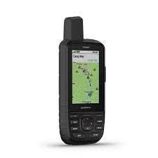
Garmin GPSMAP® 67i is a rugged handheld GPS device with integrated inReach® satellite communication technology, designed for reliable navigation and global connectivity in remote environments. It combines multi-band GNSS support with Iridium® satellite messaging, enabling two-way communication, live tracking, and SOS alerts beyond cellular coverage. With long battery life, advanced mapping capabilities, and durable construction, it is built for outdoor navigation, field operations, and expedition use.


     Key Features

  • Global satellite communication via Iridium® network
  • Two-way messaging (SMS, email, and device-to-device)
  • Interactive SOS emergency alerts
  • Multi-band GNSS support (GPS, Galileo, QZSS, BeiDou, IRNSS)
  • Preloaded TopoActive maps with routing support
  • LiveTrack location sharing
  • Long battery life (up to 840 hours in expedition mode)
  • Barometric altimeter and 3-axis compass
  • Wireless connectivity (Wi-Fi®, Bluetooth®, ANT+®)
  • Rugged design with MIL-STD-810 and IPX7 rating

     Typical Applications

  • Outdoor navigation and trekking
  • Expedition and remote exploration
  • Emergency communication and safety
  • Surveying and field data collection
  • Search and rescue operations
  • Adventure tracking and mapping

Additional information

Mechanical Specifications

Dimensions: 6.2 × 16.3 × 3.5 cm
Weight: 230 g
Display Type: Transflective color TFT
Display Size: 3" diagonal (240 × 400 pixels)

Power Parameters

Battery Type: Rechargeable internal lithium-ion
Battery Life:
Up to 165 hours (inReach enabled, 10-min tracking)
Up to 180 hours (GPS mode)
Up to 425 hours (expedition mode with inReach)
Up to 840 hours (expedition mode)

Communication & Data

Messaging: Two-way messaging (SMS, email, device-to-device)
SOS: Interactive SOS supported
Tracking: LiveTrack location sharing

Network & Connectivity

Satellite Network: Iridium®
Wireless Connectivity: Wi-Fi®, Bluetooth®, ANT+®
Interface: USB-C

Navigation & Sensors

GNSS Support: GPS, Galileo, QZSS, BeiDou, IRNSS
Altimeter: Barometric altimeter
Compass: 3-axis tilt-compensated

Mapping & Storage

Preloaded Maps: TopoActive maps
Memory: 16 GB internal
External Storage: microSD (up to 32 GB)
Waypoints: 10,000
Tracks: 250 tracks, 20,000 points

Environmental Specifications

Water Rating: IPX7
Standards: MIL-STD-810 (thermal, shock, water)